The Big View of the Appalachian Mountains Radio Link Test Network

Visit APRS.org for more details of this event.


Lastest analysis of all links from South to North.
Directory of raw files
Web Page with Summary Details

The APRS Network from Georgia to Maine
Link A between stations 1 and 2 Link B between stations 2 and 3 Link C between stations 3 and 4 Link D between stations 4 and 5 Link E between stations 5 and 6 Link F between stations 6 and 7 Link G between stations 7 and 8 Link H between stations 8 and 9 Link I between stations 9 and 10 Link J between stations 10 and 11 Link K between stations 11 and 12 Link L between stations 12 and 13 Link M between stations 13 and 14 Link N between stations 14 and 15 Overview

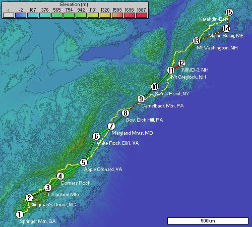
Click on a line above to view the network analysis for that particular link.

The Green lines are networks that have passed some minimum threshold of goodness based on the assumptions thus far (which may be not quite right yet, but they are close). Yellow lines are marginal. Any Red lines do not result in a VHF link for much if not any time.


Springer Mtn, GA 34.626660, -84.193750 34° 37.5996' N, 084° 11.6250' W 1,147 m (3,762 ft)
Clingman's Dome, NC 35.556330, -83.494830 35° 33.3798' N, 083° 29.6898' W 1,927 m (6,322 ft)
Cloudland Mtn 36.105160, -82.130840 36° 6.3096' N, 082° 7.8504' W 1,887 m (6,191 ft)
Comers Rock 36.760170, -81.219500 36° 45.6102' N, 081° 13.1700' W 1,190 m (3,904 ft)
Apple Orchard, VA 37.517500, -79.510000 37° 31.0500' N, 079° 30.6000' W 1,281 m (4,203 ft)
White Rock Cliff, VA 38.973130, -78.590880 38° 58.3878' N, 078° 35.4528' W 899 m (2,949 ft)
Maryland Mnts, MD 39.537700, -77.500200 39° 32.2620' N, 077° 30.0120' W 524 m (1,719 ft)
Gov. Dick Hill, PA 40.246210, -76.455550 40° 14.7726' N, 076° 27.3330' W 357 m (1,170 ft)
Camelback Mtn, PA 41.042500, -75.349670 41° 2.5500' N, 075° 20.9802' W 642 m (2,106 ft)
Sam's Point, NY 41.705000, -74.341670 41° 42.3000' N, 074° 20.5002' W 675 m (2,215 ft)
Mt Greylock, NH 42.637000, -73.167000 42° 38.2200' N, 073° 10.0200' W 1,057 m (3,468 ft)
N1NCI-3, NH 43.033330, -72.367330 43° 1.9998' N, 072° 22.0398' W 459 m (1,506 ft)
Mt Washington, NH 44.270170, -71.303340 44° 16.2102' N, 071° 18.2004' W 1,911 m (6,270 ft)
Maine Relay, ME 44.943330, -69.118330 44° 56.5998' N, 069° 7.0998' W 152 m (499 ft)
Katahdin-East 45.860000, -68.885500 45° 51.6000' N, 068° 53.1300' W 402 m (1,318 ft)

Planning for Station #6


$Id: index.php,v 1.11 2009-06-22 14:58:24 jhuggins Exp $

References, Resources, Kudos and Credits

Copyright 2009 John Huggins