Help Needed for Ham Hike in Virginia

This post is an all call for any ham radio operators in the Northern Virginia – Maryland – West Virginia area.

Bob Bruninga is organizing the second annual Golden Packet event up and down the Appalachian Trail along with some new West Coast trail activity. Last year the Virginia team was successful in placing an APRS packet repeater on White Rock Cliff. We desire to repeat the process again this year.

Details on the White Rock Cliff ARPS station are on Bob’s site…

Particularly needed is a backup APRS radio, like the Kenwood D700/D710 along with a 7 AH GelCell along with the Hiker to haul it up the mountain.

If you would like to join the hikers in this ham endeavor, please contact John, KX4O, at kx4o@hamradio.me.

[Slashdot] [Digg] [Reddit] [del.icio.us] [Facebook] [Technorati] [Google] [StumbleUpon]

Good APRS Information Web Site

Figuring out the details of the APRS “new paradigm” WIDEn-n technique has been a bit of a learning curve for me. I stumbled onto this web site which contains a good summary of the various modes.

http://www.nwaprs.info/

This site helped me shorten my APRS learning curve.

[Slashdot] [Digg] [Reddit] [del.icio.us] [Facebook] [Technorati] [Google] [StumbleUpon]

Question: APRS Software

Hello all,

So…

I am finally getting around to using APRS. It seems to me APRS applications, such as UI-View, are older and lack recent releases. I realize UI-View’s author is no longer with us. Does anyone here have some thoughts on good software for use with the APRS system?

73
John

[Slashdot] [Digg] [Reddit] [del.icio.us] [Facebook] [Technorati] [Google] [StumbleUpon]

Hiking, Hams and Hills – Station #6 of the AT Golden Packet

Virginia hikers and hams supported the White Rock Cliffs (Station #6) of the first Annual Golden Packet Event.

Summarized, we were trying to set up APRS relay stations up and down the east coast to cover and service all points along the Appalachian Trail and surrounding areas. Some RF link analysis was performed and is available for viewing at http://www.packetradio.net/events/AT_Golden_Packet_Event/ using the remarkable Radio Mobile program and A LOT of SRTM elevation data.

Of the fourteen stations planned several points were accessible only by foot. The White Rock Cliffs station was no exception.
(more…)

Confirming Radio Mobile in the AT Golden Packet Attempt

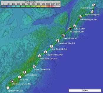
I have experimented with Radio Mobile for a few years. If you have not tried using it, you should. It is a free RF link analysis program that uses geographic elevation data to help you determine the obstacles between two radio stations.

The details of this program’s capabilities are too numerous to mention here so please visit the web site here…
(more…)